A group of citizen scientists have helped produce detailed maps of endangered habitats in Surrey.
The project forms part of a wider study to examine how citizen science, satellite imagery and machine learning could be utilised to produce detailed maps of lowland heathland.
In Surrey, trained volunteers were asked to use a mobile app to carry out hundreds of surveys in two heathland sites – Chobham Common and Puttenham Common. These observations were considered alongside satellite imagery, soil and landscape data to develop a machine learning model to predict where lowland heathland may occur in the county.
This resulted in a habitat map, produced at a resolution of three metres. This is expected to help conservationists to identify small pockets of heathland, which might be missed in broader mapping.
Conservation organisations hope that utilising citizen science will mean a faster, more cost-effective way of monitoring habitats, targeting restoration efforts and protecting biodiversity. It may also strengthen public engagement.
Since this study, the same framework has also been applied to Surrey’s fragmented chalk grassland.
Dr Ben Siggery, research and monitoring manager at Surrey Wildlife Trust, said: “Protecting nature starts with knowing where it is, but creating detailed habitat maps has traditionally required huge amounts of time and resources. Our research shows that, with the right training and support, citizen scientists can collect reliable ecological data that can be combined with satellite imagery and machine learning to help us map habitats more efficiently.”
Dr Ana Andries, senior lecturer in remote sensing and GIS, added: “Our work shows what's possible when academia, conservation organisations and local communities work together.
“Combining satellite technology, machine learning and the enthusiasm of citizen scientists, we've developed an approach that could help conservationists monitor vulnerable habitats more quickly, direct restoration efforts where they're needed most and support biodiversity recovery at a much larger scale.”
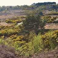
Image © Robert W Eyers/Shutterstock





 Vets wishing to access TB Advice services can now use a digital contact form, following updates announced by the APHA.